Hadrian's Wall
Hadrian's Wall: A Brief History
The construction of Hadrian's Wall first began in the reign of the Roman emperor Hadrian, and work is believed to have started by AD 122. Scholars debate how long the Wall complex took to build in its entirety and to completion, but it is significant that there were a number of stages in the construction of the Wall and its attendant elements. From the time of its construction in the early 2nd century AD, the Wall was occupied almost continuously until the end of Roman rule over Britain in the early 5th century AD, with intriguing archaeological evidence for continued occupation past the 'end' of Roman Britain.
The Wall Complex: Its Elements
Hadrian's Wall, or the Wall, is typically used as a shorthand to refer to a monumental complex of distinct components that are all linked together to create this impressive frontier work. There are 4 distinct elements: the curtain; the ditch; the installations; and the Vallum.
- Running 80 Roman miles across the Tyne-Solway isthmus - from the North Sea coast on the east of England to the Irish Sea coast on the west - is the Wall curtain. This is the element that makes up the actual wall.
- To the north of the Wall curtain is a ditch, cut sometimes in a V-shape, other times in a U-shape. Between the ditch and the curtain is the strip of land known as the berm, and at the eastern end of Hadrian's Wall, evidence for a series of obstacles have been found.
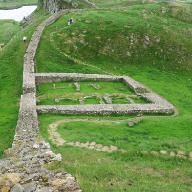
- Along the Wall itself, there is a small fortlet known as a milecastle found approximately every Roman mile, and between each milecastle are two turrets or towers. Approximately every 7 miles a fort can be found on the Wall.
- To the south of the Wall is the enigmatic earthwork known as the Vallum. This consists of a ditch flanked to the north and south by a large mound.
In addition to these 4 elements, there are other features, such as the Military Way - a paved road that ran immediately south of the Wall curtain and sometimes along the top of the Vallum north mound - and the Stanegate - a paved road that actually pre-dates Hadrian's Wall and with its own forts positioned along its length, as at Vindolanda. North of Hadrian's Wall were a series of outpost forts, and to the south of the Wall were a number of hinterland forts. All these forts were connected by the Roman road network.
The Wall also coursed through a number of different landscapes, with the lowland coastal plain in the east yielding to rolling hills and eventually the dramatic Whinsill crags and steep fell hills of the central sector, eventually returning to a coastal plain and marsh at the western end of the Wall.
What was the Wall used for?
An excellent question, and one that can spark a heated debate among experts. Opinions differ, from those who argue that the Wall had a defensive purpose to keep the barbarians out of the Roman Empire, to those who would argue that the Wall was a monumental customs barrier, controlling access into and out of the Roman Empire.
Join us on this study tour, examine the remains directly, and explore the history of this monumental frontier landscape to provide an answer for yourself!